Sunday 4 January 2015

Mam Tor & The Great Ridge

Mam Tor & The Great Ridge 04-01-15

This map was created using GPS Visualizer's do-it-yourself geographic utilities.

Please wait while the map data loads...


Route: Castleton, Cave Dale, Limestone Way, Rowter Lane, Windy Knoll, Mam Tor, Hollins Cross, Barker Bank, Back Tor, Lose Hill, Losehill End, Townhead, Townhead Bridge, Hope, Peakshole Water, Castleton

Date: 04/01/2015
From: Castleton 

Parking
: Roadside parking in Castleton
Start Point: Cave Dale
Region: Peak District Dark & White Peak

Route length: 9 miles (14.5 km)
Time taken: 03:39
Average speed: 2.5 mph
Ascent: 613m
Descent: 626m

Summits on this walk:
Mam Tor (517m), Barker Bank (426m), Lose Hill (476m)

Other points of interest: Cave Dale, Hollins Cross, Back Tor

I've been working over the festive period, bound to the house on standby for a week while missing out on the glorious weather we've been experiencing recently. People's posts and pictures of the Lake District certainly have me green with envy. I was finally freed from the shackles of work by the time the first weekend of 2015 rolled into view so Sara and I planned a short trip to a mountain ridge in miniature - Edale's Great Ridge.

Though of fairly modest elevation throughout its length, the ridge sits splendidly isolated dividing the picturesque Vale of Edale and Hope Valley and surrounded by some of the finest scenery the Peak District has to offer. I have done this walk a couple of times, once when I was still in short trousers and didn't care much for walking and another when it snowed and rained in equal measures so today was probably the first time I've really been able to appreciate the beauty of the undulating hills.

We started off by heading away from the ridge, taking a route south that leads into the depths of Cave Dale. The dry limestone valley is a real highlight of the Hope Valley, formed by glacial meltwater thousands of years ago. The walls of the lower section closest to Castleton are some 50m tall and almost perpendicular to the ground, casting a dark shadow across the entire valley. The Limestone Way, a long-distance route from Castleton to Matlock, runs up the length of Cave Dale and, despite the slippery ice, the route is easy enough to follow though steep in places.
The craggy walls of Cave Dale
The narrowest part of Cave Dale
Cave Dale
At the top of the steepest section, the valley swings west but not before offering a fine view of Peveril Castle backed by the sun-drenched Lose Hill. The castle, founded after 1066 and now owned by English Heritage, occupies a commanding position on the hillside overlooking Castleton. It's not hard to imagine where the village gets its name from.
One of the many caves in Cave Dale
Cave Dale and Peveril Castle
Cave Dale with Lose Hill behind
After the views begin to fade away, the valley loses its aggressive rockiness and begins to peter out becoming greener and shallower in the process. Eventually, it disappears altogether, the path leading across enclosed farmers fields. I imagine it's quite a surprise to someone travelling in the opposite direction.
The shallow beginning of Cave Dale
We left the Limestone Way, now bound for Mam Tor a short distance away. The route follows a straight line along the walled Rowter Lane until it meets and crosses the main road into Castleton from the west. It was here that we started to become part of the crowds that were also out enjoying the fine weather, there were quite literally hundreds of people about. We passed the cave of Windy Knoll before crossing the road again and starting the short climb up Mam Tor.
Leaving Cave Dale
An adjacent track leading back to Castleton
Mam Tor on the horizon
A drystone wall near Rowter Farm
Mam Tor
The Great Ridge
Thanks to its popularity, the route from here is well paved and from here to the end of Lose Hill there's no requirement to even contemplate looking at a map, even in the worst weather. After the climb, the expansive views that the walk is famed for begin to appear; Hope Valley to the east, Edale and Kinder Scout to the north and the ridge-backed profile of Rushup Edge to the west. It's a delight, especially on a day like today.
The road leading into Edale with Kinder Scout behind
Rushup Edge and Edale
Rushup Edge
Jacob's Ladder and Crowden Clough
We reached the summit along with many others and had a quick wander around, particularly over to the edge of the famous landslip that lends itself to Mam Tor's name. The meaning, mother hill, is a reference to the small hills that were formed as the land slipped away from the eastern face some 4,000 years ago. That landslide, and the continuous movement since are the result of weak shales underlying sandstones, a common phenomenon all around the Dark Peak though nowhere is it better demonstrated than at Mam Tor.
Mam Tor's trig pillar
The landslide
The landslide once again
Like many hills around Great Britain, the summit is encircled by an early Iron Age hill fort, thought to date from around 1200. The trig point on the summit of the hill is placed on top of a tumulus which probably dates from the Bronze Age, and a bronze axehead has also been found here suggesting that the summit has been occupied for a much longer period.
The Great Ridge and Hope Valley
The Great Ridge
Mam Tor forms the western terminus of what is known as The Great Ridge which runs for 2 miles to Lose Hill and is roughly paved along its length the prevent erosion. A long sweeping arm falls from Mam Tor to Hollins Cross, the lowest point along the ridge before it picks up again over Barker Bank. The low point of Hollins Cross is a popular location, particular for people crossing between Hope and Edale as well as people joining the ridge to Mam Tor or Back Tor. It is named after a cross that stood at the site until 1905.
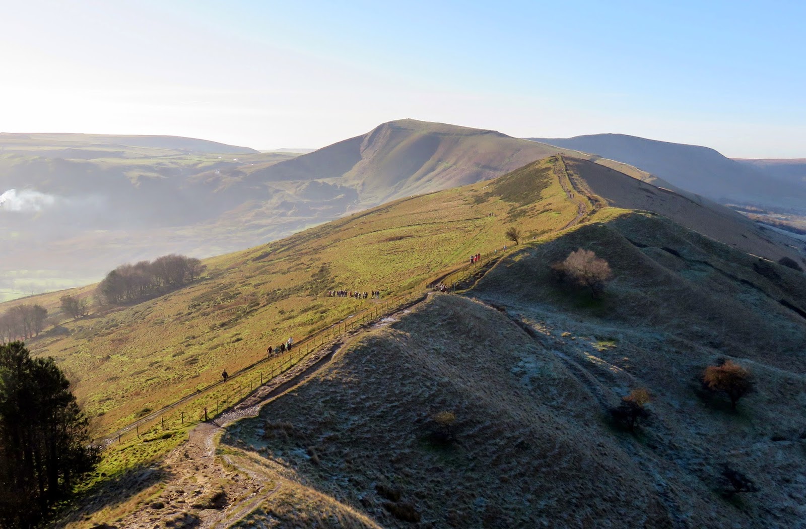
Barker Bank, Back Tor and Lose Hill
The paved surface that accompanies most of the route
Hope Valley
Mam Tor
An old pair of gate posts
Hollins Cross
Mam Tor from Barker Bank
Back Tor and Lose Hill
After crossing Barker Bank, the imposing crag of Back Tor presents the steepest climb of the day, though only a short one. The crag was formed after being exposed by a landslide, similar in nature to the much larger one on Mam Tor. We chose it as a suitable place to break for lunch as it offers a stunning view of the ridge heading back to Mam Tor as well Edale and the slopes of Kinder Scout.
Back Tor
The climb up Back Tor
Numerous people came and went as we sat contemplating the view before it was our turn to continue on. I had thought that the number of people might dwindle away the further we travelled from Mam Tor but they just kept coming. It's not difficult to see that it is estimated that the Peak District is the most visited national park in the country.
Barker Bank and Mam Tor
Edale
One final climb lay before us, that of Lose Hill. The origins of its name are steeped in myth and legend. The story goes that King Cynegils of Wessex gathered his forces on Lose Hill and marched on Northumbrian soldiers based on Win Hill. Despite their superior numbers, Wessex was defeated by the Northumbrians by rolling boulders down upon them, giving rise to the two named hills (Lose and Win). Sadly, there is no record of this battle in any Anglo-Saxon source so it perhaps should be regarded as a myth. 
Cairn at Back Tor
Win Hill from Lose Hill
From the toposcope on Lose Hill, we descended down towards Hope. A long path follows the ridgeline to Losehill End and ultimately into the village of Hope itself. Though slippery, the path is easy to follow. We reached Hope in good time and, after crossing the main road, set our sights on returning to Castleton. We chose to follow the footpath parallel to Peakshole Water, a pleasant river that drew our attention away from the looming chimneys of the Hope Quarry.
Lose Hill
The muddy track to Losehill End
Penfold in Hope
There were many areas on the path back that still had a crisp coating of white frost, evidence that the valley receives no sunlight during these short winter days. We crunched our way along, back to Castleton's welcoming, narrow streets and the chance for one final up-close look at Mam Tor.
Lose Hill
Mam Tor over Castleton
We drove up Winnats Pass, a remarkable road if ever there was one, winding up a geological cleft. The pass was once thought to have originated as a giant collapsed cavern; however, a more recent explanation is that it was a ravine between the coral reefs that originally formed the limestone.
Winnats Pass
Aiming for the Blue John Cavern, we parked at the end of the road that used to pass along the slopes of Mam Tor. This section proved highly prone to movement (as I've mentioned earlier), especially after periods of heavy rain, and was in constant need of repair. It was finally abandoned in 1979 and left in ruin. It's an eerie sight seeing the road being consumed by the irresistible force of nature. After one final view of the Hope Valley and Great Ridge bathed in early evening light and we were back in the car, bound for home after a thoroughly successful day walking.
The Great Ridge
Mam Tor
The crumbling road beneath Mam Tor
Back Tor and Lose Hill
The Hope Valley

No comments :

Post a Comment