Saturday 12 December 2015

Alport Castles

Alport Castles 12-12-2015

This map was created using GPS Visualizer's do-it-yourself geographic utilities.

Please wait while the map data loads...


Route: Fairholmes, Lockerbrook Coppice, Lockerbrook Heights, Pasture Tor, Rowlee Pasture, Alport Castles, Little Moor, The Tower, Alport Farm, Alport Bridge, Rowlee Bridge, Rowlee Farm, Woodcock Coppice, Hagg Side, Fairholmes

Date: 12/12/2015
From: Fairholmes


Parking: Fairholmes
Start Point: Fairholmes
Region: Peak District Dark Peak

Route length: 8.3 miles (13.3 km)
Time taken: 03:56
Average speed: 2.12 mph
Ascent: 681m
Descent: 708m

Summits: The Tower (460m)

Other points of interest: Alport Castles

We had chosen a truly miserable day to visit Alport Castles; one of the Peak District's most dramatic landscape features. It was raining heavily when we started and was still raining heavily by the time we finished. We even had some snow thrown into the mix. Fortunately, there was only a light wind and the poor weather meant we could grab one of the free car parking spaces at Fairholmes early on a Saturday morning.

Fairholmes is a large car park located between the Ladybower and Derwent reservoirs, close to the magnificent Derwent Dams; solid masonry dams built in the 1900s to provide water for practically the whole of Derbyshire. They were so similar to the famous German dams in the Ruhr valley that they were used to train the Dambuster pilots of World War II, much to the annoyance of the locals.
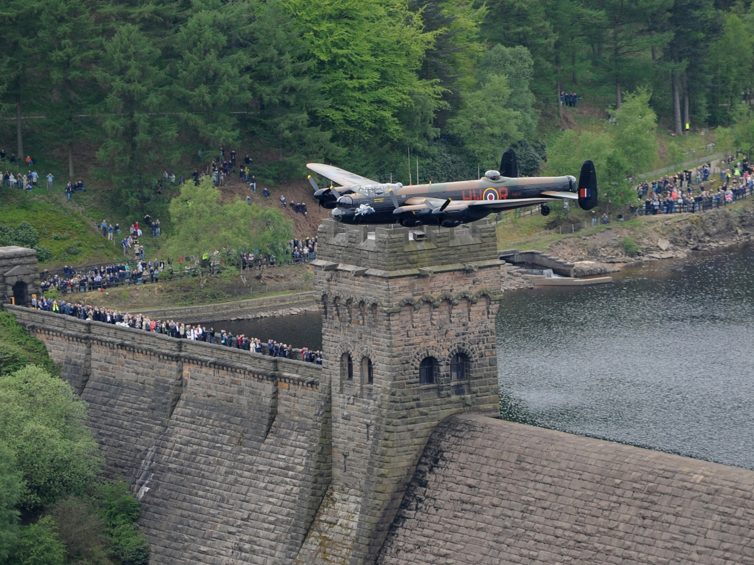
The Lancaster over the Derwent Dam this summer 
After grabbing an early cup of tea, we set off in search of a route up through the trees of Lockerbrook Coppice. A signposted path wends its way up the hillside to the Lockerbrook Outdoor Centre where we set about bashing our way through the trees of Lockerbrook Heights; entirely off-piste, until we emerged on top of Rowlee Pasture, an extended finger of moorland that climbs all the way up on to Bleaklow, not that we'd be heading that far.
Climbing up through the woods of Lockerbrook Coppice
Lane near to the Lockerbrook Outdoor Centre
The blurry depths of Lockerbrook Heights
On the western edge of the moor, overlooking the Alport Valley is a well-used path that gains a stone slab covering not far along its length. This path would take us all the way to Alport Castles and is a straightforward stroll, the only slight challenge coming from the sleet and snow that was beginning to settle.
Rowlee Pasture
Snow begins to settle on the ground
The route is flagged for much of its route
The drystone wall leading to Alport Castles
We marched on with nothing in the way of a view to keep us company until we reached a crossing of drystone walls and the final leg to Alport Castles. The path stops abruptly at a steep edge that falls a number of metres down into the valley, marking the beginning of the large landslip that forms this remarkable place.
Looking to Little Moor
The cliffs of Alport Castles
The exact cause of the landslide is unknown, but similar if less dramatic landslips occur all around the Dark Peak, notably on Mam Tor. 300 million years ago, the area was part of a river delta that flowed into a shallow tropical sea that covered the Peak District. For millions of years, the mud and sand deposited by the river compressed to form the layers of soft shale and hard gritstone rocks which can be seen today. One theory is that the River Alport eroded the softer layers, causing the landslide.

The path hugs the cliff tops, peering down into the chaos below but the poor weather made things difficult to see, which was a real shame as this is unlike any other place in the Peak District. We backtracked slightly to Little Moor, following a path that leads down to the depths of the landslip. Thousands of scattered rocks and boulders litter the place, clear evidence of the cliff walls collapse. It is never really clear from photos just how big this area is, some half-mile long and tens of metres high. Everything still looks perilous, almost like it could slip or collapse at any time and nowhere is this more evident than The Tower.
We dropped down to the tumbled stones
Mounds of rock litter the valley
The Tower emerges from the gloom
The Tower - much taller than it appears here
The Tower is perhaps the reason behind Alport Castles' unusual name. From all angles it looks almost exactly like a motte and bailey castle, standing proud in the centre of a huge amphitheatre of cliffs. It is accessible from nearly all sides and climbing it is difficult to resist. We avoided some of the steeper looking ways up thanks to slippery rocks but edged around to the north side which is a much more straightforward climb. I mentioned the crumbling nature of the rocks, here you can see huge rocks that look almost like shattered glass, huge cracks run across them in all directions and it is these rocks that appear to be holding the whole thing up, myself included.
Looking up The Tower
Top of The Tower
Looking down from The Tower
Me atop The Tower
With evidence of reaching the top saved on the camera, we retreated back down to the foot of The Tower and began a slippery descent towards Alport Farm that nestles in the very heart of the Alport Valley and was the birthplace of suffragette Hannah Mitchell.
The cliff face at Alport Castles
Alport Farm
Alport Farm
Alport Castles from Alport Farm
We followed the lane from the farm towards the Snake Road and, though it was still raining, the clouds had lifted a bit to reveal Alport Castles across the valley which was enough to warrant risking the regular camera in the rain. The farm track (and much of the rest of the walk to be honest) lacks any of the excitement of Alport Castles and is a straightforward stroll along signposted paths and tracks. We did pass an interesting structure on the River Ashop, a large labyrinth weir and diversion, taking a significant amount of the water from the river. I assume it's a feature to channel water into one of the reservoirs, maybe someone could enlighten me?
The Alport Valley
Barrage on the River Ashop
Rowlee Bridge led us back across the River Ashop and up towards Rowlee Farm. Here, a zigzag track takes you beneath Bellhag Tor and into the extensive woodland of Hagg Side. Unlike our morning endeavours, a warn path wound down the hillside through the trees depositing us almost right on top of the cars.
Looking along the Ashop valley from Rowlee Farm
Misty woods at Hagg Side
We hadn't really stopped all day, aside from clambering up The Tower, and it was only a short time after lunch when we finished - enough time to dispose of wet waterproofs and descend on one of my favourite shops in the country; Outside in Hathersage. Not only do they have a great range of gear to fondle, but they also have an excellent café which is the perfect place to dry off after a wet day in the Peaks. Alport Castles will have to be done again, in more favourable conditions next time, which is no real hardship.

No comments :

Post a Comment