Saturday 10 December 2016

Crimpiau, Craig Wen & Creigiau Gleision

Craiglwyn & Creigiau Gleision 10-12-2016

This map was created using GPS Visualizer's do-it-yourself geographic utilities.

Please wait while the map data loads...


Route: Capel Curig, Nant y Geuallt, Crimpiau, Craig Wen, Moel Ddefaid, Craiglwyn, Creigiau Gleision, Creigiau Gleision North Top, Hendre, Blaen y nant, Nany y Geuallt, Capel Curig

Date: 10/12/2016
From: Capel Curig


Parking: Capel Curig National Park Car Park
Start Point: Capel Curig
Region: Carneddau - Snowdonia

Route length: 9.0 miles (14.5 km)
Time taken: 04:33
Average speed: 2.0 mph
Ascent: 974m
Descent: 984m

Summits: Crimpiau (475m), Craig Wen (548m), Craiglwyn (623m), Creigiau Gleision (678m), Creigiau Gleision North Top (634m)

The weather more or less dictated the choice of this walk. Eager to get out but hamstrung by low cloud and the threat of rain, we chose to avoid any of the high Carneddau and opted for the easternmost summits of the range - the modest peaks that form Creigiau Gleision.

There are three main summits on the Creigiau Gleision ridge; that of Creigiau Gleision itself, its North Top and the southern peak of Craiglwyn. In addition, we'd be tackling two minor peaks; the delightful Crimpiau and Craig Wen.

After a restful night in Manchester, a crack-of-dawn start wasn't required - it's an easy drive along the North Wales coast, ultimately ending up in Capel-Curig, a small village that holds the dubious honour of being one of the wettest places in the UK.
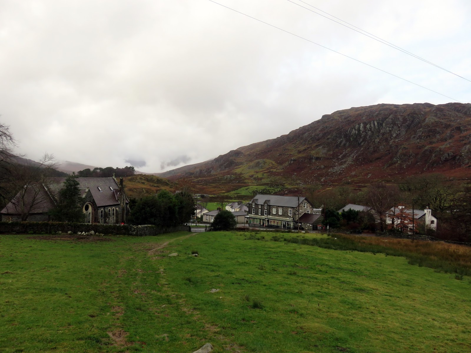
Morning in Capel Curig
We parked up in one of the National Park car parks behind the excellent Joe Brown's. With one eye on the clouds swirling around, we set off, crossing the A5 and joining the bridleway that links Capel-Curig with Trefriw, once an important trade route.
The bridleway as it leaves Capel Curig
Clogwyn Mawr
The path passes through some modest woodland
Looking back towards Cefn y Capel
The path passes the church of Saint Julitta, from which the village takes its name as tradition claims this chapel to be the 6th-century foundation of St. Curig, a Celtic bishop. The bridleway climbs into a hanging valley above Capel-Curig which seems a million miles away from the busy road below. Nant y Geuallt has a laborious task of flowing through here - I'm sure most of it gets trapped in the valley bogs before it gets a choice to join the Afon Llugwy.
Crimpiau up ahead
Clogwyn Mawr over Nant y Geuallt
The path climbs easily further, reaching the summit of the pass before it descends towards Llyn Crafnant. Here, we diverted off, following another, much smaller path that would take us to the summit of Crimpiau. The climb is straightforward, following a path not marked on the map and, before long, we reached the cloudy summit.
The wall at the top of the pass
A peep into Llyn Crafnant
Climbing Crimpiau
Approaching the summit
The summit of Crimpiau
Views from Crimpiau are supposed to impress though cloud covered much of it today. There were an exciting couple of moments when the Ogwen valley was revealed along with the unmistakable serrated outline of Tryfan. While the clouds were briefly parted, we were able to plot our route across to Craig Wen, a prominent crag at the head of the Llyn Crafnant valley.
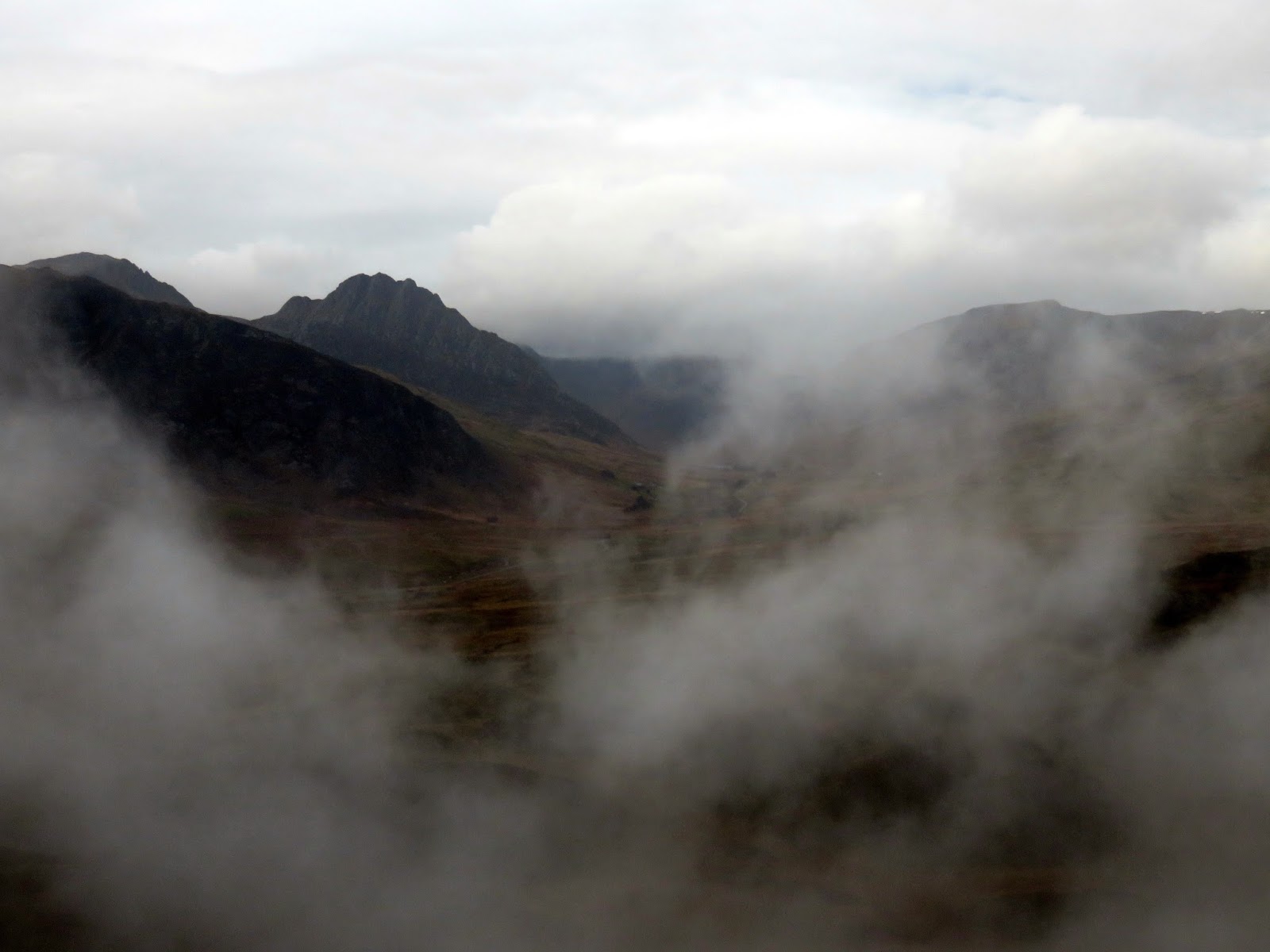
Tryfan makes a brief appearance
We groped our way through the mists, following a drystone wall for the most part. Again, there is a path on the ground not marked on the map that did lead us up to the summit. There wasn't much joy to be had on Craig Wen so we continued on towards the Creigiau Gleision ridge. After briefly dropping from Craig Wen, the route climbs up around the outcrop of Moel Ddefeid heading for Craiglwyn.
Craig Wen
Looking towards Cefn y Capel 
Craiglwyn, despite being the southern end of the Creigiau Gleision ridge, is both tall enough and prominent enough to be classed as a Nuttall in its own right though we had to spend a few minutes consulting the map in the mists in order to find it. After a quick snack break, it was on to Creigiau Gleision itself - the highest point that is, which stands almost immediately north of Craiglwyn over a boggy depression.
On the hunt for Craiglwyn
Craiglwyn
The summit of Craiglwyn
The misty Creigiau Gleision ridge
Approaching the summit
As we made our way to the summit, the clouds eventually, albeit slowly, started to lift and we could see glimpses of Pen Llithrig y Wrach across the valley and the immense Llyn Cowlyd below. Creigiau Gleision is the easternmost of the Carneddau, to the east the slopes eventually reach the Afon Conwy and the boundary of the Snowdonia National Park.
Creigiau Gleision's summit
Looking back to Craiglwyn
Creigiau Gleision's summit
The views, which were now clearing, are extensive including the coast to the north and Snowdon to the southwest along the valley of Dyffryn Mymbyr. More boggy ground lies in wait between the main summit and the outlying North Top approximately 1km away. Views down the cliffs of Marian-mawr into Llyn Cowlyd are impressive.
Looking north towards the middle top
Sun catches the pools on the summit
Looking west into the Ogwen Valley
Creigiau Gleision's North Top
Pen Llithrig y Wrach
Creigiau Gleision's North Top
Pen Llithrig y Wrach over Llyn Cowlyd
Creigiau Gleision's North Top
We had considered two routes to return to Capel-Curig; one via the shores of the reservoir and one through the woods above Llyn Crafnant. With the threat of afternoon rain, we chose the latter, if the rain arrived as forecast we'd have some moderate shelter for a time.
Looking northeast over Afon Ddu and Moel Eilio
Getting to the woods requires the crossing of numerous bogs and marshes, the final straw being a stile over a fence located on the other side of a very wet and no doubt deep bog. Why? Could the stile not have been built on the near side of the bog? I think it was a cruel joke. Either way, we managed to cross unscathed - just.
The bog with the stile on the other side
We followed a faint path across yet more bogs to the edge of the woods where a stile crosses the boundary fence. Surely the woods would provide a respite from the water? Not a chance. Through dry in the occasional place, the route through the woods was more river than a path, culminating in a crossing of a fairly deep stream.
Feeling festive
Entering the woods
The woods above Llyn Crafnant
The stream crossing
We emerged from the woods at Blaen y nant, relatively unscathed after our adventure. Blaen y nant sits at the end of the Crafnant valley, the same valley we had peering into earlier in the day - now we were in the depths of it though it is very pleasant. Our route back towards Capel Curig required a short climb out of the valley, up to the point on the path where we had left it to climb Crimpiau earlier in the day.
Waterfalls
Crimpiau at the head of the valley
Llyn Crafnant
Llyn Crafnant over Blaen y nant
Craiglwyn and Clogwyn yr Eryr
Crimpiau
A steady rain had started to fall but, by now, we were retracing our steps around Nant y Geuallt to the path that leads back to the car. Despite the weather, a few fleeting glimpses of Tryfan made all the difference to this walk. We were actually quite lucky that the forecast didn't hold true and, despite the last half hour or so, remained largely dry (overhead at least). As I had thought when beginning this walk, we didn't encounter another soul all day; I imagine these modest hills would be a good option to avoid the crowded summits of the Glyders or Snowdon.
The last view into Llyn Crafnant
Moel Siabod through the gap in the hills
Clogwyn Mawr
Heading back towards the woods
Capel Curig

No comments :

Post a Comment